|
No mass tourism, but genuine travel. BEDAWI lasts longer...
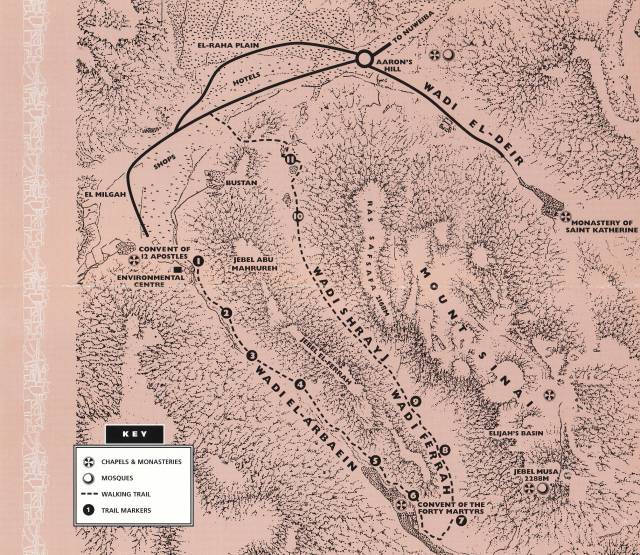
Getting Started
We meet up with our Bedouin Guide and we will start our walk from St. Katherine village to the mouth of Wadi Arbai'in where an established camel path wanders up for 3 km until the Monastery of the Forty Martyrs. Here the trail veers north-east into Wadi Ferrah. Continuing for 2 km, you will reach the beginning of Wadi Shrayj. (See map the area map) Caution! The descent down Wadi Shrayj is moderately steep and rocky, but your Bedouin guide will lead you down the safest path.
"Before mid-day we had again reached the convent of 'El Arbai'in'... The verdure was so brilliant and blossoms of the orange trees diffused so fine a perfume that I was transported in imagination..." Burckhardt 1822
What will I see?
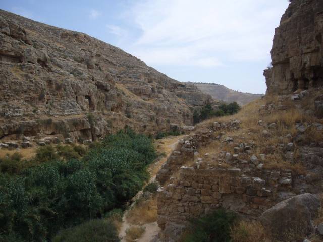
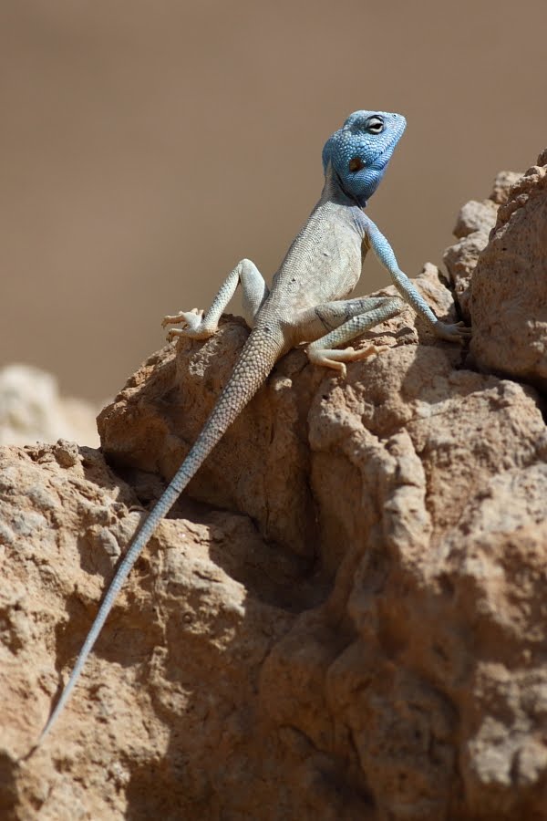
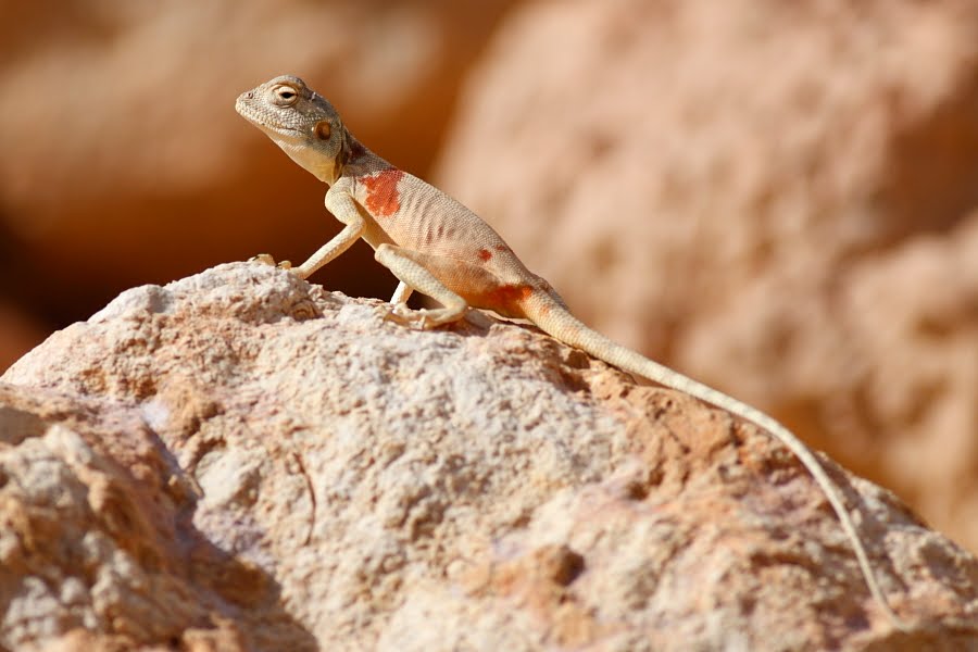
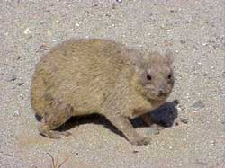
The walk through Wadi Arbai'in, Wadi Ferrah and Wadi Shrayj is framed by the high red granite columns of Gebel Ahmar (Red Mountain) and Gebel Safsafa (Willow Mountain). These peaks provide a spectacular backdrop to the colourful and subtle activity of life in the wadi’s. If you look carefully, you will discover unique and interdependent relationships between the people, places, plants and animals. Smell the fresh scent of aromatic plants such as wild oregano, Pyrethrum and Artemisia as it wafts through the wadi. Look for bees pollinating Alkanna wildflowers and the blue-coloured Sinai Agama lizards basking on red rocks. The shy and reclusive rock hyrax can be seen at a Bedouin family's enclosure.
You will experience the history and importance of religious sites such as the Rock of Moses and the Monastery of the Forty Martyrs. Vistas of Mount Sinai and MountKatherine are awe-inspiring and in the ancient ruins of Byzantine dwellings nestled in Wadi Shrayj you can imagine the life of the original inhabitants.
Site 1 – GARDENS BEHIND THE RESEARCH CENTRE
The large boulders at the mouth of Wadi Arbai'in are a clue to the force of the floods that carry them down from higher elevations. The floods, resulting from occasional heavy bursts of rain and melting of winter snow, also transport soil and seeds, recharge the groundwater and prepare the wadi for a new season of growth.
The irrigation technique practised in the adjacent stone-walled gardens is more reliable and organised than the floods. Wells up to 10 metres deep tap underground water sources which support apricot, almond, olive, pomegranate and fig trees as well as date palms and grape vines.
The black plastic pipes (Khartoum) are used to channel well water for irrigation and drinking water to local people. Be careful not to tread on or damage them.
The gardens to the south and the nearby storeroom belong to the Monastery of St. Katherine. The lower garden is part of the Suez Canal University Environmental Research Centre.
Continue along the path approximately 600 metres to Site 2.
Site 2 – MAKE A WISH 'HAJAR EL MAJARI'IN'
To the Gebeliya Bedouins this large boulder covered with small rocks is a wishing stone. When making a wish, they throw a small rock on the top of the boulder.
If the rock remains on the top, the wish will come true, but it the rock falls off, it will not.
The tips of ancient cypress trees can be seen above the wall of the Monastery garden further up the path.
Walk about 600 metres and follow the garden wall to Site 3.
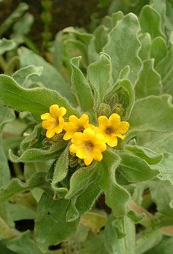
Site 3 – THE STORY OF 'ALKANNA' AND 'ANTHOPHERA'
This rocky basin is home to many interesting species which share special inter-relationships. Like all flowering plants, the Alkanna species which you see here needs to be pollinated in order to produce seeds for the next generation. A local territorial, solitary bee species called Anthophera plays an important role in the pollination of Alkanna. Each spring (March-June), while the Alkanna is flowering, the bee collects nectar and pollen from it. It will eventually line the chambers of its underground burrow with the pollen to feed its young which will emerge the next spring. The Akanna and Anthophera need each other.
Nature note Alkanna (Lebed) is a low bushy herb with long green hairy leaves that produces yellow flowers in spring and carpets the ground after rain. It occurs in low lying sandy areas in wadis around St. Katherine village. The genetic differences, evident in the varying flower size and shape, between Alkanna populations in different wadis are of great scientific interest.
Walk about 300 metres to Site 4.
"...we passed a block of granite, said to be the rock out of which the water is issued when struck by the rod of Moses... The rock is about twelve feet (366 cm) in height, of an irregular shape approaching to be a cube. There are some apertures upon its surface, through which water is said to have burst out." Burckhardt 1822
Site 4 – ROCK OF MOSES AND CHAPEL OF THE PROPHET MOSES
Today you can see the same twelve fissures described by Burckhardt on the face of the rock which is now enclosed by a stone wall next to the chapel of the Prophet Moses. Monks relate that this is the rock which followed and sustained the children of Israel during the Biblical time of the Exodus. ...'for they drank of that spiritual Rock that followed them: and that Rock was Christ' 1 Cor. 10:4.
Water no longer flows from the rock clefts but there are accounts of pilgrims drinking there. The Gebeliya Bedouins believe that the clefts represent the twelve springs referred to in the Quran when Moses struck the rock (Sura 2:60).
Burckhardt noticed the Bedouins putting 'grass into the fissures, as offerings to the memory of Moses... They also bring their female camels, for they believe that by making the animal crouch down before the rock... and by putting some fresh grass in the fissures of the stone, the camels will become fertile and yield more milk.'
The engraved footprints seen on surrounding rocks are an old way for Bedouin to propose marriage.
Continue for another 700 metres to Site 5.
Site 5 – MONASTERY OF THE FORTY MARTYRS
Surrounded by a green belt of olive, cypress and popular trees, the Monastery of the Forty Martyrs was constructed in the sixth century in honour of the forty Christian martyrs who died in Sebaste (central Turkey).
Monks relate that forty Christian soldiers from the Roman army in the third century, where commanded to worship pagan gods. They refused and were put to death by being exposed at night to the bitterly cold winds off a frozen lake. Those who survived until morning were killed by the sword. Today the gardens are looked after by the members of a Bedouin family. In the grounds of this monastery is a chapel dedicated to the hermit Saint Onuphrius. Coming from Upper Egypt, he was said to have lived for seventy years in the rock shelter at the northern end of the garden, until he died in AD 390.
Caution! Please respect the religious importance of this site by not trespassing or trying to gain admission.
Nature note The Sinai agama (Harduun) is a robust, 30 cm long flattened lizard. Males turn characteristic bright cobalt blue during the spring breeding season. Perched on rocks they survey and defend their territory and their female mates.
Follow the Monastery wall for about 350 metres and take the path to the right to Site 6.
Site 6 – RAMADAN'S HYRAXES
Ramadan has an enthusiastic interest in rock hyrax (Wabr) and has constructed an enclosure at his home to observe and enjoy these rabbit-sized mammals. Beginning with four captive individuals, the hyraxes have multiplied over the years. Ramadan occasionally releases the hyrax offspring once they reach maturity. The leafy green "roquette" and grape leaves grown in the family garden and the Bedouin bread (Fatiir) are part of the captive hyrax's diet.
Ramadan and his large family are very hospitable and will usually serve you and your guide tea as you watch the hyrax. Show your appreciation by making a contribution.
Nature note The shy and reclusive rock hyrax typically lives in colonies in rocky valleys and feeds on vegetation. Its closest relatives are the elephant and sea cow. The hyrax produces highly concentrated urine which forms a crystalline mass in its burrow. Bedouins collect this substance for medicinal use and as a natural wood preservative.
Traditionally hyrax meat was eaten by women just before they gave birth.
Return from Ramadan's house to Site 6 and continue along the path for 250 metres to Site 7.
Site 7 – JUNCTION OF 'WADI ARBAI'IN' AND 'WADI FERRAH'
Wadi Ferrah meets Wadi Arbai'in at the foot of Gebel Ferrah.
To the west behind Ramadan's house you see the peak of Mount Katherine (Gebel Katherine) with a white chapel. Mount Katherine is the highest mountain in Egypt. Its rocks are different from those of the other mountains nearby as it is composed of 'young', 10 million year old, dark rhyolite, a volcanic rock, similar to granite but with a finer grain.
The red granite (Ikna) makes up the surroundings peaks: Gebel Ferrah, Gebel Safsafa and Gebel Ahmar, which are formed from 580 million year old basement rock. Mount Sinai (Gebel Moussa) is overlaid with a more recent diorite, the result of a volcanic activity during the Miocene epoch, about 10 million years ago.
The Gebeliya Bedouins recognise that the darker volcanic mountains like Mount Katherine form a ring-shaped boundary (which geologists refer to as a circular dyke) to their red-granite territory. They understand that the environment of the dark mountains is hotter and harsher, with little shade, and so the life cycle of plant on the dark mountains is shorter than in the red granite areas.
Nature note Dykes (Jidda) are the stripes of volcanic rock intrusions which sometimes stretch for kilometres and can be many metres in width. Dykes are usually a darker red or grey colour than the surrounding rock and are more permeable to water than the harder granite. Underground springs are more likely tapped here than anywhere else. Plants grow more easily along dykes and animals congregate to feed and take shelter here.
Bedouins refer to dykes as Jidda, meaning grandmother - the nurturer, the nourisher. Jidda is probably also a corruption of the formal Arabic word Gaedda, which means dyke.
Wadi Arbai'in separates Gebel Moussa and Gebel Katherine and is considered to be a holy tract of land.
"... the wadi is looked upon by the Arabs as particularly sacred. They believe that no robbery can be perpetrated there without immediate detection, and that if a man be afflicted with any malady whatever were to sleep within its precincts he would experience instant relief. Here the 'spirits' are said to hold nightly revel and celebrate fantasias to the sound of sweet music." Edward Palmer 1871
Bear left at the fork into the wadi for about 400 metres to Site 8.
Site 8 – GRAZING EXCLOSURES OF THE RESEARCH CENTRE
The fenced plots of land on the left are being used to study the effects of sheep and goats grazing on the vegetation. The study will examine and assess the response of plants without grazing pressure: the number of species, their distribution and density. Compare the vegetation inside the enclosure plots to the surrounding outside.
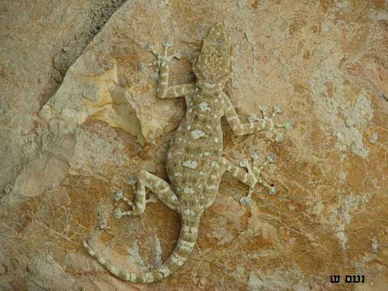
Nature Note The Fan-toed gecko (Nataaga) feeds on insects like mosquitoes and can cling to vertical surfaces. The undersides of their flared-toed feet are covered in large plate-like scales. These scales are covered with thousands of microscopic branched hairs that allow the gecko to grip onto all surfaces, even upside down.
The Gebliya Bedouins are pastoral nomads and have a long history of grazing sheep and goats but grazing pressure has increased in the last 70 years with a rise in the local population. One Gebeliya man relates that "120 years ago there were only 40 families living in the Uzbeliya territory. Today the Bedouin population is over 5000 and pressure on the land has increased with plants being eaten before they can set seed".
The Bedouin solution to this problem is the traditional practice of Hilf - a restriction on grazing in a given area, for a certain time, to allow for the regeneration of plants. Hilf demonstrates the inherent knowledge of ecology and conservation of the local peoples and their ability to find solutions to local problems.
Continue along the path approximately 400 metres to Site 9.
Site 9 – BEDOUIN SHELTER AND GARDEN
The stone shelter and adjacent gardens belong to the family of Ramadan (Site 6). A nearby concave boulder enclosed by stones and a tiny door is a storehouse and shelter for produce from the garden.
Shepherdesses are frequently seen in their colourful 'Gelebayas' and black cloak and veil, playing their flute (Shabaaba) while grazing their goats and sheep on the rocky slopes of Wadi Ferrah and Gebel Safsafa, the red granite peak you can see rising to the north-east.
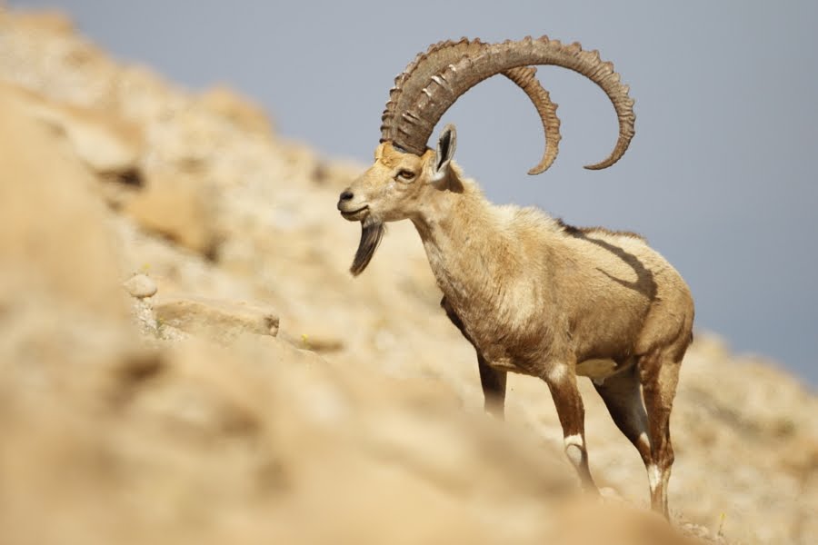
Nature note The Nubian ibex (Taytal) has a pale brown coat; white belly and black marking on the flanks, forelegs and muzzle identify this type of wild mountain goat. Males and females usually live in separate groups. Males can weigh up to 90 kilograms and develop heavy curved horns up to 1 metre long.
A small and elusive Nubian ibex population drifts between the rocky peaks of the mountains Safsafa, Ahmar and El Dier. It is only the very fortunate and observant visitor that catches a glimpse of these animals.
The ibex population has become threatened by over-hunting and also because they are particularly sensitive to disturbance by humans. Ibex must drink every 2 - 3 days in the summer and every 10 days in the winter, but will not approach water sources when there are people present.
Caution! Please assist the Protectorate in the conservation of this species by keeping water sources accessible and clean and reporting all sightings (including location, number, time, date and gender) to the Protectorate Office in St. Katherine village.
Continue for about 1200 metres to Site 10.
Site 10 – WADI SHRAYJ
The spectacular long open view across Wadi Sheikh to the Plain of El Raha from the rock wall marks the beginning of Wadi Shrayj. The banana-shaped mound at the mouth of the Plain of El Raha, and now covered with hotels, is a prominent local landmark clearly decipherable on historical maps of the area. Neolithic artefacts from between 7000 and 4500 BC have been located in this area.
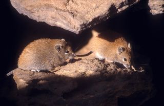
The ruins of several ancient dwellings and structures from the Nabataea (200 BC - 100 AD) and Byzantine eras (300 AD - 700 AD) are located in ‘Wadi Shrayj’. Among the rocks of the old buildings you may see a golden coloured mouse searching for food.
Nature note The Spiny Mouse is named after the coarse spine-like hairs that cover its back. It can often be seen climbing through boulders. It has a unique temperature control system which allows it to survive in extreme temperatures.
Continue and you will find your last site about 350 metres down the wadi.
Site 11 – BYZANTINE DWELLINGS
Rounded-walls, niches and shelves and tiny doors are typical of Byzantine stone dwellings. Notice how the stones are laid without mortar and the absence of a roof. You can also find traces of ancient water systems or conduits which were used to direct rain water to the settlement and for irrigation use.
Typical of the Byzantine era (3rd to 7th century AD) water conduits or channels directed the mountain rains to cisterns or pools. Water conduits were constructed using natural drainage lines in the granite and by cementing flat stones with a natural mortar.
The outdoor courtyards are thought to be an area for meeting guests and for cooking. The small stone hutch was built by Bedouins to keep chickens safe at night from foxes.
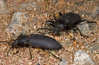
Nature note Tenebroid (Awair El Banaat) is a beetle which, unlike most other beetles, can not fly. Its black body, sealed wing case and long rigid legs are adaptations to hot day-time conditions.
The Bedouin name Awair Al Banaat stems from a game that young Bedouin shepherdesses play: the girls tie the beetles to one another with cotton threads and the beetles follow each other like a train.
From this vantage you then descend down to the asphalt road either by following the wadi floor past Bedouin houses and gardens or by crossing over the saddle in front of you.
On reaching the asphalt road, St. Katherine village lies to your left and indicates the end of the trail.
|