|
No mass tourism, but genuine travel. BEDAWI lasts longer...
Getting Started
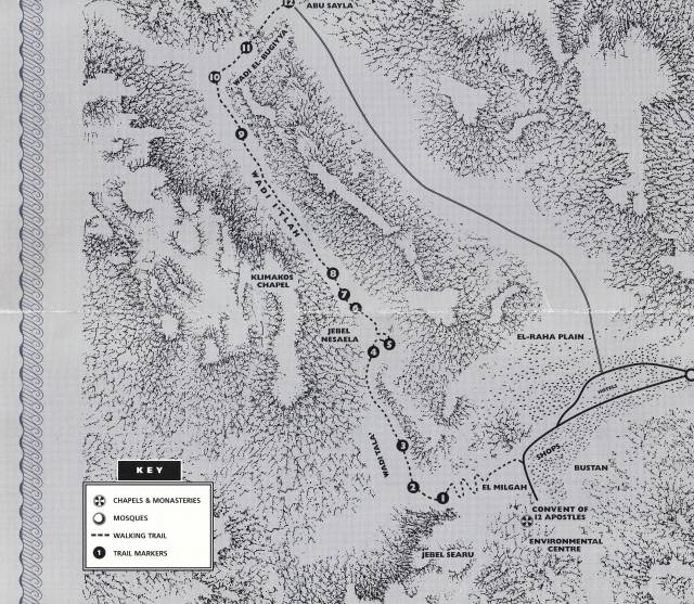
We meet up with our Bedouin Guide and we will start our walk from St. Katherine village from El Milgah winding up and over the lowest pass of Gebel Searu into Wadi Tala (See map). After 2 kilometres Wadi Tala merges with Wadi Itlah. Another 3 kilometres further on Wadi Itlah meets Wadi El Bugiyyah which leads you through a narrow water-worn gorge to the Bedouin village of Abu Sayla, about 2 kilometres away.
There is vehicle access which means you can either be collected at this point or make the 5 kilometres walk back into St. Katherine village.
What will I see?
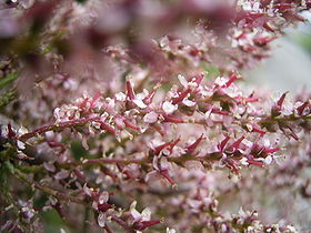
Listen to the sounds of splashing and spluttering water seeps and springs as you walk between the red granite walls of Wadi Tala and Wadi Itlah. Evidence of the presence and passage of water can be seen in many of the chasms, clefts and fissures along the trail. This precious water supports a chain of green Bedouin orchards along the wadis as well as sustaining much natural vegetation and wildlife. The Tala Monastery, the Chapel of St. John Klimakos and several hermitages reflect the religious importance and the opportunity for solitude in the area.
Site 1 – TOP OF PASS GEBEL SEARU
A steadily rising and winding path brings you up to the top of a pass across Gebel Searu, from which you can view the town of St. Katherine behind you while in front Wadi Tala waits below.
"Many people come to this point for the view. It is beautiful because it is like you are in an aeroplane - you can see everything" says Sadala Hussein, whose Gebeliya Bedouin family have been the custodians of the Tala Monastery gardens and have lived in the wadi for hundreds of years. Through remarkable skills of observation and an in-depth understanding of natural law, the Bedouins have a profound connection with the landscape. A Bedouin man once said:
"I am tied to my country by my navel-string. For when a child is born, the father buries the navel-string and the placenta deep in the ground".
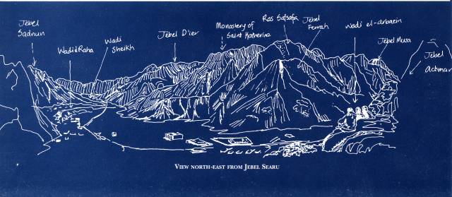
You can use this panoramic sketch to identify the surrounding natural features and landmarks:
Descend about 200 metres to Site 2, overlooking Wadi Tala.
Site 2 – SADALA HUSSEIN'S GARDEN
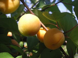
... grapes, almonds, pomegranates, plums, apricots, peaches, beans, dates, apple, aubergines, pears, melons, lemons and prunes...
The extensive and colourful gardens of the Hussein family extend up the wadi from the Monastery's long, sparse olive grove. The gardens are irrigated from David's Waterfall (said to be a resting spot for King David in Biblical times) at the upper end of Wadi Tala via an elaborate system of plastic pipes and pools.
This private garden is one of about 400 orchards in the 200 square kilometres of Gebeliya territory. One to two metre high stone walls which follow the land's natural form are characteristic of these orchards. Fruit bearing trees and a wide range of vegetable crops are grown and the main harvest time is summer. In summer many Bedouins leave their valley homes for several weeks to tend and work their mountain gardens.
The Gebeliya are highly proficient at orchard agriculture. Their skills, notably grafting and irrigation, are inherited - along with seeds and root stock - from the monks and hermits who came from the Mediterranean regions to St. Katherine from the 3rd century onwards. These Bedouins often graft domestic orchard varieties onto drought-tolerant wild root stock - such is the case with the pears Sadala has grafted onto wild hawthorn trees in his garden.
Cultural note The well worn paths around the gardens of Wadi Tala and Wadi Itlah are familiar to the camels carrying the summer harvest of fruit and vegetables to the marketplace in St. Katherine. Adapted to life in flatter areas, the camel can only manage to carry heavy loads by following the hand built trails which link the mountain gardens. Many of these trails date back several hundred years.
Turn right and gradually descend about 350 metres to Site 3.
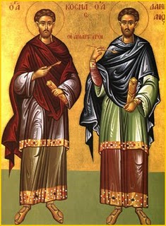
Site 3 – TALA MONASTERY
Situated amidst a long olive grove and some tall cypress trees is the Tala Monastery of Cosmas and Damianos. Cosmas and Damianos were a twin, born in Arabia and early Christians. Both were doctors who administered free health care to local people in the 3rd century AD, and who were martyred during the Roman persecutions.
In previous centuries the olives from Tala were taken to the Monastery to be crushed and pressed to extract oil. Today the olives from the Monastery garden are harvested and taken by camel and then by truck to the city El Arish in North Sinai. Some of the olives are preserved and bottled, and others are pressed to make fine oil. The products are then transported back to the Monastery of St. Katherine where olive oil is burned in the Church lamps, used in the kitchen and also distributed to the Bedouins.
Walk about 1 kilometre along the wadi to reach Site 4.
Site 4 – AYN TUFAAHA
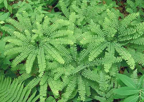
At Ayn Tufaaha below to your left, water drips from a shallow arch into a sandy basin hidden behind massive boulders. Ayn Tufaaha means Apple Spring, as its water sustains apple trees and other plants in neighbouring orchards. Sometimes during the summer this spring dries up and the only evidence of water is the dormant mats of moss, white water marks on the rocks and a profusion of maiden-hair fern (Shar Al Banaat means girls' hair).
Cultural note Bedouins have many descriptions of water: the way it flows, how much there is, how long it stays. Naggaat is a dripping place like Ayn Tufaaha. Galt refers to red-granite pools connected to a seep. Kharaza (bead) is an elongated pool in red-granite which has no underground water source. Bir is a well typically dug 4 or 5 metres deep in volcanic dykes or in the land. Masak (to grasp) means a water eroded depression in red granite which hold water after rain and Umshaash is a water hollow which retains water for a short time after rain. Such descriptions and observations are telling clues about the detailed knowledge Bedouins have of this precious resource in this mountains desert.
As you continue down to Wadi Itlah you will find a series of pools nestling in fine reddish sand. During the warmer months bright green algae forms small carpets on the surface of the water.
Continue around the bend for about 300 metres to Site 5.
Site 5 – WADI TALA & WADI ITLAH JUNCTION
The path ahead will take you back to St. Katherine. Instead, take the lower path, entered by a small gap in the side of a stone retaining wall, which goes directly into Wadi Itlah. From here you can see the marked effect of the thin curtains of water that run off the rock face after rain, staining it white and leaving a V-shaped indentation.
About 200 metres further down the path, the garden on the right side of the path incorporates what is believed to be a ruined Byzantine monastery. The monastery was referred to as a prison because of the low ceiling and doorways and lack of windows. The 'prisoners' were monks who lived inside these cells as an act of repentance, having to crouch uncomfortably as a part of their self-imposed spiritual suffering.
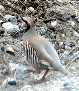
Nature note The Chukar partridge (Shinaar) is a stoutly built bird, around 30 cm high and most easily identified by its loud, high-pitched call: "Chuk, chuk, chuk, chukar". With a white throat, reddish tail, white barring on the flanks and black breast band, the Chukar partridge is regularly seen scuttling around rocky wadis.
Turn left and continue on for about 500 metres to Site 6.
Site 6 – HERMITAGES
A reinforced stone path leads past a boulder with a concave face. Beneath this face is the ruin of a stone hermitage from the Byzantine era, identified by the stone niches inside and the stone lintel supporting the tiny door. On the left hand side of the hermitage is a small semi-circular enclave which is believed to be the remains of a kiln used to produce a natural lime mortar which is made from deposits on the rocks of waterfalls and used in building.
Around the 3rd century Christian hermits lived in remote small huts, or in alcoves formed by large boulders or rock walls around Mount Sinai. They were seeking refuge from the Roman persecution of Christians as well as a spiritual haven.
The hermitages were typically located near water sources for drinking and for cultivation. Can you see evidence of ancient gardens?
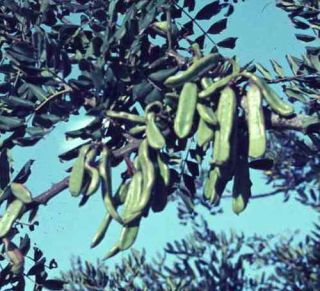
Growing 30 metres to the north of the boulder is a grand old carob (Kharuub) tree with an old well located at its base. The well has been covered over by Bedouins to prevent animals contaminating the water.
Keep left and continue for about 150 metres to Site 7.
Site 7 – EL AGRUDAYA
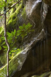
The tiered waterfall of El Agrudaya, below the right, hosts a profusion of life after rain. Water beetles, dragonflies, crickets and other insects thrive amid the moss, maidenhair fern and bulrushes.
The constant presence of water has helped shape the granite pools. The mineral composition of the rocks with the water very slowly dripping is creating bowl-shaped depressions. The chemical reactions also leave a white lime residue on the surface of the waterfall face. This is the white substance which causes streaks on rocks described at sites 4 and 6.
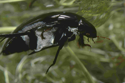
Nature note Tiny ripples across a pool of water will alert you to the presence of the small black water beetles. Its rounded streamlined body helps it glide on the water's surface, propelled by its broad hairy legs.
Follow the path for about 250 metres to Site 8.
Site 8 – SAINT JOHN KLIMAKOS
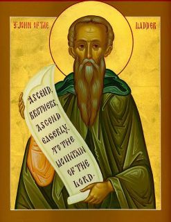
From this point, midway up the left slope of the wadi you can see the white domed Klimakos Chapel, built in 1979. The Bedouin refer to the recently built stone shrine as Gallili Mags. This site commemorates the devotional work of Saint John Klimakos (or Saint John of the Ladder), who spent 40 years of solitude in a cave above the existing chapel during the 6th century. During this time, Klimakos was elected Abbot of Sinai and was asked to write a spiritual guide.
He composed The Ladder of Divine Ascent which likens spiritual life to the ladder seen by the Patriarch Jacob extending from earth to heaven (Genesis 28:12-17). The book is a classic work and is read and treasured to this day by monks and laymen who visit the chapel for prayer.
Historical Note "Silence brings us closer to God". The Ladder of Dive Ascent, as written by Saint John Klimakos, consists of 30 rungs, each step corresponding to a spiritual virtue. Through silence and solitude hermits and monks sought to climb the divine ladder. The first rung instructs the renunciation of all earthy ties and the next 14 relate to human vices such as talkativeness, anger, despondency and dishonesty. The final 15 rungs relate to virtues including meekness, simplicity, prayer, holy stillness and humility. The crowning virtue is love.
Continue on about 1500 metres to Site 9.
Site 9 – WALLS AND GARDENS
These gardens of exotic fruits and vegetables were established centuries ago by monks and hermits. Nowadays Bedouins have virtually taken complete ownership of the orchards but still return a portion of the produce to the Monastery.
These gardens are tended by three Bedouin families from the Awlaad Jindi clan (Abu Zeituna, Abu Harouma and Karam El Rahp). Above the gardens stands a large century-old mulberry tree. It is said to be a public tree, and is said to be the first tree to bear the seasonal fruit and the last to lose it.
The ruined garden walls and houses are testimony to the floods of 1968 and 1969, the greatest in living memory. Most of the stone walls were reconstructed after these storms and several low dams, built to prevent future flood damage, can be seen.
Cultural note Located about 500 metres from Site 8; at the foot of the mountain to the left you will find El Hilefiya, a small garden which demonstrates Hilf, an important conservation practice of the Bedouins. Hilf is a tradition of seasonal restriction on the grazing of goats and sheep and the harvesting of wild plants in a certain area. El Hilefiya bears an apricot tree and the ripening of its first fruit indicates the end of Hilf, when grazing can begin again in this section of the wadi. The first rain of autumn marks the new season of Hilf.
Follow the wadi bed for about 500 metres down to Site 10.
Site 10 – WADI ITLAH & WADI EL BUGIYYAH JUNCTION
Several large date palms mark the intersection of these two wadis. Wadi El Buggiyah leads north-east to Abu Dayla about 2 kilometres away. Dry waterfalls, steep smooth faces and rock tunnels with dashes of green moss and vegetation create enchanting niches and reflect the presence and land-shaping powers of water.
Climb about 300 metres up the narrow wadi to Site 11.
Site 11 – TASTE THE MANNA
The wadi opens up to form a small sandy basin with tamarisk trees (Tarfa). The tamarisk excretes a substance called manna as a result of the activity of two different types of aphid-like insects. They suck the rich sap from the foliage and the excess sap forms small globules which crystallize and fall on the ground.
This substance is thought to be the Biblical manna.
Nature note The tamarisk (Tarfa) tree stands up to 5 metres in height. Its greyish-green leaves are very small and scale-like. The Bedouins say that a poultice made of Tarfa will relief and neutralise the sting of scorpions and the bite of snakes.
Manna was a traditional food and is believed to be one of the substances which sustained the Israelites during the events of the Exodus around 12oon BC. Biblical accounts describe manna "like coriander seed; it was white and its taste was that of wafers made with honey" (Exodus 16:31). Manna provided the miraculous sustenance of the Israelites - God ordered Moses to keep some of it for posterity: "Fill an omer of it to be kept for your generations that they may see the bread wherewith I have fed you in the wilderness when I brought you forth from the lad of Egypt" (Exodus 16:32).
Note Omer is an ancient Israelite unit of dry measure.
Search the ground and branches for the freshest manna, sticky and clear. Taste a little, if you are lucky enough to find some.
Return to Site 10.
From here your Bedouin guide will show you the safest route, which climbs up over knobbly and stepped rocks, out of the wadi. Pause to look back in the direction from which you have come and view Jebel Katherine in the distance. The sound of the wind echoing through the narrow chasm of dark volcanic rock is likened to the sound of a Bedouin trumpet. El Bugiyyah refers to a horn or trumpet.
Continue 900 metres to Site 12.
Site 12 – FATHERS OF THE TORRENTS ABU SAYLA
Your arrival at Abu Sayla is signalled by the large boulder Hajar Garesha. This boulder formed one wall of a dwelling which five centuries ago was the home of the first inhabitants of Abu Sayla.
Today a mosque, a school and over 70 houses built from the local granite occupy the undulating plain. The village started out as a winter retreat for Uzbeliya pastoralists and gardeners when the temperatures and winds of the higher elevations became too inhospitable, and was like a ghost town during summer - deserted for the spring pastures above 1600 metres, garden harvests, and the solitude of the mountains.
Nowadays the majority of the Gebeliya Bedouins are no longer pastoralists and do not practice the vertical migration as they did in the past. Tourism keeps many families here during the summer as men work as guides, cameleers and restaurateurs in and around St. Katherine village.
The location of Abu Sayla (sure flooding of water) just above the El Bugiyyah gorge which floods regularly, explains the name of the village.
Historical note Abu Sayla is part of an old route to the east cost of Sinai. Pilgrims, travellers, soldiers, messengers and merchants all passed through this village on foot and camel on their way from the plain of El Raha to Nagub Hawa, Sheikh Awaad, via Wadi Islaff and Wadi Hebran to reach El Tur on the east coast of Sinai. This route was made popular by Abbas Pasha in the 19th century.
As you travel down the plain of El Raha towards St. Katherine village, take a visual note of the other impacts of tourism on the Bedouin lifestyle, the environment and the religious and monastic traditions.
By participating in "soft" cultural and eco-tourism such as hiring a Bedouin guide or by camping in the mountains, you are supporting the conservation of this delicate eco system and its local people.
You are helping to maintain the rich traditions of the Bedouin and finally you have the opportunity to learn from their vast and profound knowledge of the land and life in South Sinai.
|