|
No mass tourism, but genuine travel. BEDAWI lasts longer...
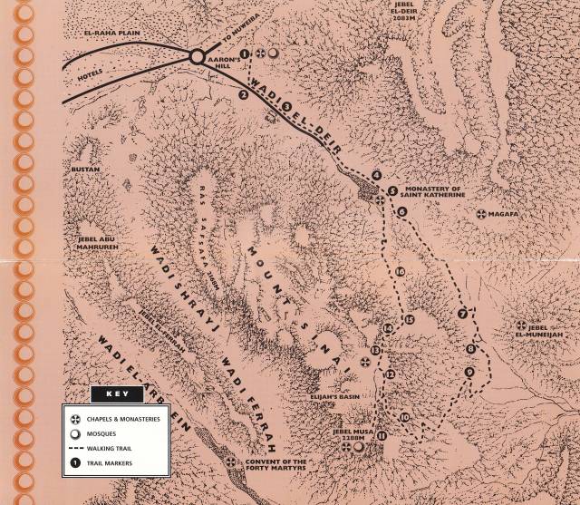
Getting Started
Read the Biblical account of the Exodus as summarised here and use the numbers to identify those sites at which some of the events are widely believed to have occurred.
The interpretative trail begins at the mouth of Wadi El Deir at Aaron's Hill (Nabi Harun) and continues past the Monastery of St. Katherine, up the camel path to the top of Elijah's Basin, then follows the stairway to the summit of Mount Sinai. The trail descends back to Elijah's Basin and then continues down The Stairway of Repentance to return to the Monastery (See map).
The length of the trail is approximately 7 kilometres and you should allow 5 to 7 hours to complete it, depending on your fitness level. The trail follows the least strenuous route but is rocky in places and care should be taken especially descending the stairway. The traditional route for pilgrims to prove their worthiness of the ascent is to climb The Stairway of Repentance.
What will I see?
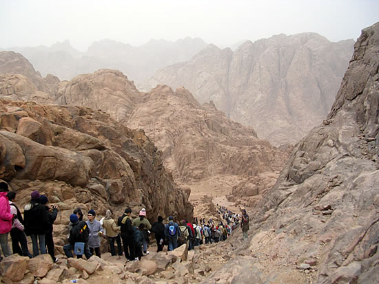
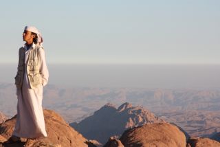
You are one of thousands who have set out to climb Mount Sinai (Gebel Moussa). Pilgrims, travellers and visitors have been attracted to the religious landscape of Mount Sinai for centuries. As you descend the path your Bedouin guide will help you identify the chapels, mosques and the other sacred sites you will see and also describe the dramatic events such as The Burning Bush and the receiving of The Ten Commandments that happened in this part of the Sinai desert between 3500 and 3200 years ago.
For some the ascent is merely a physical experience but those who choose to understand the history of the God-Trodden Mount and respect its 1600 year old monastic tradition, will undoubtedly discover something more spiritual.
From the path you will see churches, chapels, mosques and sacred sites nestled in basins and standing peaceably on summits. These places represent a common link in the faith of Christians, Jews and Muslims. Biblical accounts and the Qur'an describe the exalted events that occurred "in the Sinai desert" (Exodus 19:1) between 1500 and 1200 BC.
The local Bedouin tribe, the Gebeliya, also have a particular regard for Mount Sinai as a Holy mountain and over the centuries the Gebeliya and many other Bedouin tribes have developed a unique relationship with the Monastery.
The monastic tradition grew from the 3rd century, when many early Christians sought refuge from the persecution of pagan Rome in the holy mountains of South Sinai. Relics of these Roman and Byzantine times can still be seen on the mountain in ancient quarries, paved paths and stairs, hermitages and water conduits.
The Monastery of St. Katherine continues today in Orthodox Christian tradition; however, the pressure of secular tourism threatens to change this. Your efforts to appreciate the significance of this unique landscape and understand the history of the monastery are important to their conservation and continuity.
Please treat the area with respect and encourage others to do the same. Do not damage or remove anything from the area and stay on the paths.
EXODUS
Moses was discovered as a baby in a papyrus basket floating amongst rushes at the edge of the river Nile. The Pharaoh at the time had commanded that all newborn Hebrew boys be thrown into the Nile, but his daughter found the baby, rescued him and brought him up in the Pharaoh's court, naming him Moses.
As a young man Moses was sentenced to death for assaulting and killing an Egyptian foreman, who had beaten up an Israelite labourer, and to escape execution he fled into the Sinai Mountains. Here he met and married one of the seven daughters of Jethro and lived for forty years with his father-in-law, tending his flocks and cleansing his soul.
One day God revealed himself to Moses in the miracle of The Burning Bush and ordered Moses to save the children of Israel from captivity.
God parted the Red Sea to allow six hundred thousand Israelites to be led to the plain beneath Mount Horeb (now Gebel Moussa and Gebel Safsafa).
Moses spent 40 days and 40 nights on Mount Sinai, during which time God presented him two stone tablets inscribed with The Ten Commandments.
While waiting for Moses to return, they were visited by Moses' brother Aaron, who made them a statue of a golden calf to worship.
On returning from Mount Horeb, Moses was so outraged at this worship of an idol that he smashed the tablets. He then returned to the mountain where God instructed him to carve two new tablets. At Moses' request God also revealed himself in a flash of light, but first He cut a cleft in the rock to shield Moses from his blinding glory.
Exalted, Moses descended the mountain with the new tablets and instructions from God to lead the people to the land of Canaan (present day Israel).
The Israelites built The Ark of the Covenant to house the tablets, and The Ten Commandments of the Lord became the basis of Jewish and Christian religion and its social organisation.
"Now this is the great and flat valley wherein the children of Israel waited during those days when holy Moses went up the Mount of the Lord and remained there forty days and forty nights..." Etheria, a Spanish pilgrim around 400 AD
Site 1 - THE PLAIN OF EL RAHA & AARON'S HILL
The walk starts from the top of a small hill (Nabi Harun) where a white Christian chapel and a Muslim shrine stand, both of them dedicated to the Prophet Aaron. The hill is at the mouth of Wadi El Deir opposite the plain of El Raha also called Wadi Muka'das, the Holy Valley. The site is reputedly where Aaron and the Israelites made the golden calf while Moses was on Mount Sinai.
The view of the Monastery from this point is outstanding. The arrangement of rocks and small circular buildings on the south-western side of Aaron Hill is a Gebeliya Bedouin cemetery. Traditionally the graves were shallow and marked by a single upright rock but today they are more elaborate.
Walk about 250 metres, past the cemetery and across the road towards a small walled garden.
Site 2 - THE GOLDEN CALF
On the rock face to the right, near the foot of 'Megalo Manna Garden' is a rock in the shape of a calf. The Bedouin call it 'Al Bagara' (the cow) and believe that the Israelites used it as a mould for their idol.
Follow the road for 500 metres towards the Monastery.
Site 3 - THE 'ASKAR': BARRACKS OF ABBAS PASHA
These stone ruins on the road to the Monastery are the remains of the mid-19th century barracks built for Abbas Pasha's soldiers and workers. (We learn more about Abbas Pasha at Site 6). The barracks were organised around two main courts and a mosque. The mosque was located on the side of the ruins closest to the Monastery.
Continue past the tourist police station and along the dirt road which gradually ascends towards the Monastery of St. Katherine which is reached in about 10 minutes.
Site 4 - ROMAN QUARRY
As you walk up the road look carefully at the lower slopes of the mountains on your left. These were stripped of loose stones to expose solid granite for quarrying. This quarry was the source of the first building blocks for the foundations of the monastery, the church and its fortification in the 6th century. The architecture of cut stone seems to have gradually abandoned after the Arab conquest in the 7th century, although loose stones were taken from this quarry as late as the 19th century.
Look for the cut faces, chisel marks on flat rock surfaces and horizontal trenches used to wedge the blocks of granite away from the rock.
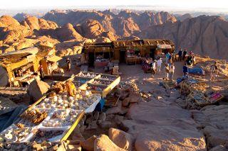
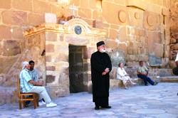
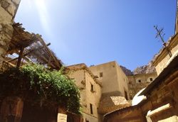
Site 5 - MONASTERY OF SAINT KATHERINE
In 1822 Burckhardt recorded a monk telling him, that if the Monastery of Saint Katherine "had been subject to the revolutions and oppressions of Egypt or Syria, it would long ago have been abandoned; but Providence has preserved us by giving us Bedouins for neighbours".
The Monastery and Gebeliya Bedouin share a very close and interdependent relationship. In the past, the Gebeliya depended on the supplies and services that the monastery provided while the monastery was reliant on the local people for manual labour and protection.
The Gebeliya Bedouin are (unlike the other Bedouins in Sinai) descendants of soldiers and servants, who were sent by Emperor Justinian (See below) to build and maintain the monastery 1400 years ago. Intermarrying with local nomads and converting to Islam, the Gebeliya maintain beliefs about the sacred landscape which derive from Christian as well as Muslim traditions.
Cultural note A Gebeliya Bedouin explained the significance of Mount Sinai to his people: "My family has been on the mountain for 1400 years. It is a Holy place to us. Not only do we depend on it for our livelihood, but our sick people climb the mountain to talk to God and ask for health and fertility. I've been climbing this mountain since I was fourteen - the mountain and I know each other well."
Today the Gebeliya Bedouin continue to be employed by the monastery as gardeners, stonemasons, grounds men, bakers, blacksmiths, carpenters and general labourers. Traditionally, all disputes not settled by Gebeliya people have been presented to the Archbishop of the Monastery to resolve.
Since the 3rd century Christian monks and hermits settled in small monastic communities around Mount Sinai to escape persecution and follow a life of prayer and devotion in the Holy mountains.
In 330 AD Saint Helena, Emperor Constantine's mother, erected a small church at the site of The Burning Bush, to commemorate the spot where God appeared to Moses, and a tower to serve as secure shelter for the monks. In the 6th century, the Byzantine Emperor Justinian ordered the building of a fortified monastery encompassing the church and tower.
Tradition relates that the relics of the martyr Saint Katherine were borne by angels to the summit of MountKatherine, where they were discovered and transferred to a reliquary in the basilica in the 9th century. From that time the place has become known as the Monastery of Saint Katherine.
Frequent attacks between the 15th and 17th centuries caused the gates of the monastery to be walled up and people and provisions were hauled up by rope and pulley. Evidence of this system can be seen on the north-eastern wall of the monastery.
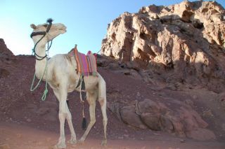
Site 6 - CAMEL PATH
The camel path begins from behind the monastery near the camel station where Bedouin cameleers offer rides up Mount Sinai, stopping just short of Elijah's Basin.
The remaining 750 steps must be climbed on foot.
The camel path was constructed by Ibrahim Abbas Pasha, ruler of Egypt from 1849 - 1854. In 1853 he visited Sinai with plans to build a palace on Mount Sinai. The palace eventually was built on the summit of Gebel Abbas Pasha, a mountain west of St. Katherine village, from where its ruins can be seen.
The Stairway of Repentance begins about 200 metres to the right of the camel station and can be seen winding up the steep, rocky gorge (See Site 13). The remains of ancient walls can be seen in the mound to the right of the path; this archaeological site has not been excavated.
Continue up the path for about 900 metres to Site 7.
Site 7 – GEBEL EL DEIR PATH JUNCTION
Facing the engraved stone number, the red granite massif rising to your left is Gebel El Deir (The Mountain of the Monastery). You can see several shrines, hermitages and gardens in the mountain crevices. A zigzag path leads to a small monastery. It can be seen more clearly from Site 9.
The small mountain to the south, i.e. on your right, is called Jethro's Mountain (Gebel El Muneijah - Calling of God). This site is where Jethro and his daughters were supposed to have lived when Moses first came to Mount Sinai and where he saw The Burning Bush and spoke to God.
The small white church on its summit is dedicated to both Saint Theodore the Commander and Saint Theodore the Tyro, or Recruit - Roman soldiers who were martyred. Behind you, to the south-west, the furthest peak is your first view of Mount Sinai's craggy double summit.
Continue up the path for about 1 kilometre to Site 8.
Site 8 - SADDLE BETWEEN WADI EL DEIR & WADI ISBAIYAH
To your left, at the top of the pass, you look south into the wide, sandy valley of Wadi Isbaiyah which formed part of an ancient trade route connecting the Monastery to both Palestine and Cairo. Camel caravans came over the pass below, marked by a pile of stones and colloquially called Nagb'i Deir, bringing food and supplies as well as pilgrims, scholars and other travellers to the Monastery from the port of El Tur on the east coast of Sinai.
Below, you can also see a small Bedouin village and gardens which are stone walled to keep out animals.
Follow the path for a further 600 metres to Site 9.
Site 9 - GALAKTION AND EPISTEME
Site 9 is located on a bend in the camel path. Looking across to Gebel El Deir, you can see a green tree midway up the mountain. To the left of this you find the Monastery of Saint Episteme, a nun, and Saint Galaktion, a monk, who lived in the 4th century.
Historical note Galaktion was the son of pagan parents who, in spite of sacrifices to idols, had been childless until they were advised by a priest to pray for a child to the God of the Christians. Galaktion was born and brought up as a Christian; he later married Episteme, also a Christian.
They devoted their lives to God and became monastic's. They settled in Sinai along with their followers to follow a life of devotion and to escape religious persecution but were captured by the Romans and martyred in the arena in Alexandria.
To your right you have a good view of the switch-back path leading to Saint Theodore's chapel on the green tinged mountain of Gebel El Muneijah.
Continue on for about 1200 metres, passing 4 separate cafeterias, to Site 10.
Site 10 - CAMEL STATION AND CUTTING
From the camel terminus, you climb through a narrow pass in the mountain which was cut through, to continue Abbas Pasha's path to the summit. Evidence of the holes drilled for the explosives to blast open the way can be seen on the sides of the path.
Nature note On some rock faces a black leaf-like pattern can be seen. Some people believe that the patterns were caused by divine light, so intense that it imprinted the shadows of living plants on stone and that it is reminiscent of the leaves from The Burning Bush. Geologists call this pattern dendrites and say it is formed by a chemical reaction which leaves a manganese deposit.
Do you see the Rays of God or do you see Dendrites?
After the pass, the path leads left to the summit of Mount Sinai and right to Elijah's Basin.
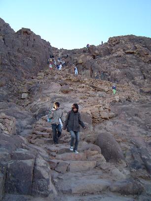
Turn left and climb the final 750 steps to Site 11: the summit.
It will take about half an hour.
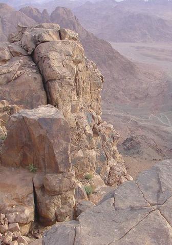
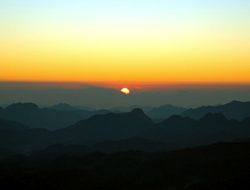
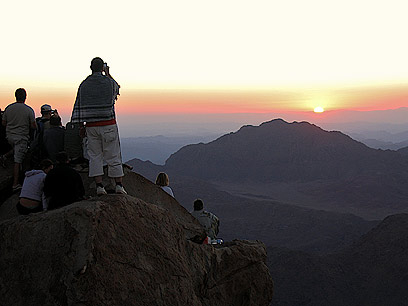
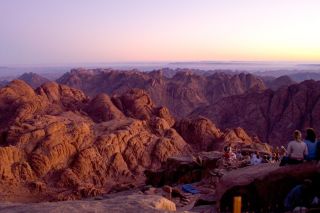
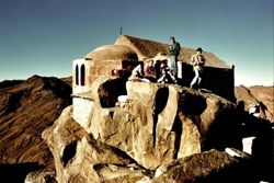
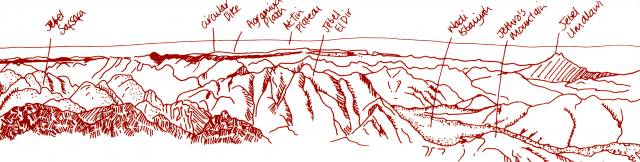
Site 11 - TO TREAD ON HOLY GROUND, THE SUMMIT OF MOUNT SINAI
"Nothing can exceed the savage grandeur of the view from the summit of Mount Sinai. The infinite complication of jagged peaks and varied ridges, and their prevalent intensely red and greenish tints..." Edward Hull 1885
The final steps of The Stairway of Repentance take you to 2.285 metres above sea level and the lofty summit of Mount Sinai. The view from here has been likened to "an ocean of petrified waves".
Sometimes it is possible to see the hazy blues of the Gulf of Suez in the east and the Gulf of Aqaba in the west from this point.
The northern and eastern boundaries of the Gebeliya territory are demarcated by the dark volcanic circular dyke and the peaks of Gebel Um Alawi.
Use this panoramic sketch to orientate yourself and locate landmarks.
Christians and Muslims have long regarded this summit as the sacred Mount Sinai, although Jewish tradition is more guarded in ascribing an earthy location to Mount Sinai. In early Christian times, it was only the pious that walked up the mountain in barefooted reverence and who were permitted to visit the summit. Pilgrims rarely slept here and to this day the Bedouin respect the Holy Mountain by leaving with their flocks before sunset.
The practise of sleeping on the summit to watch the sunrise is something of the last couple of years and the problems caused by waste and overcrowding disappoint many visitors. If you are camping, please sleep at Elijah's Basin and never on the summit.
You can use this sketch to orientate yourself.
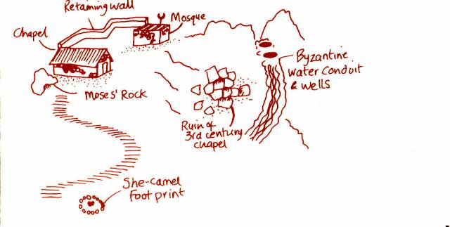
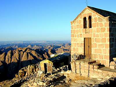
The altar of the Church of the Holy Trinity is said to be built over the rock where God created the Tablets of the Law.
Adjoining its northern wall, behind an iron fence, is the cleft in the rock from where Moses beheld God's glory.
Many people believe that the marks inside the crevice are the imprints of Moses' back, hands and head where he "shrank back into the rock while the glory of the Lord passed by".
At the end of the 4th century, Etheria, a pilgrim, writes of worshipping in a chapel at the top of Mount Sinai.
In the 6th century, under Emperor Justinian, a new basilica-type chapel, with two side aisles, was built of cut granite. It was much larger than the present church, extending to the edge of the present mosque.
The basilica was destroyed in the 11th century along with many other Christian shrines by the Fatimid ruler El Hakim.
The Monastery was spared because of the letter of protection in which Prophet Muhammad (pbuh) declared "a secure and positive promise" to defend the Christian establishment and because it also had a mosque inside the walls.
The extend of this 6th century church can be easily traced on the western slope of the summit. The altar of the basilica is thought to have been incorporated into the existing Church of the Holy Trinity (built in 1934).
Many of the large pink granite blocks were quarried from Elijah's Basin. The circular Christian cross in stone relief found on some of the blocks is indicative of the Justinian era.
Next to the church is a mosque which also incorporates some of the blocks from the earlier church. Beneath the mosque is a small grotto with a prayer niche which was probably a crypt of the original basilica. Neither the church nor mosques are normally open to visitors.
About 40 metres below the summit are the remains of a Byzantine water conduit which fed the cistern between the two small rock knolls. Other conduits can be found on the mountain.
Return by the stairs, approximately 200 metres down from the chapel, to the left of the Stairway.
Marked by a ring of rocks you will find an impression which resembles the footprint of a camel in the rock. Some Gebeliya Bedouin claim it is the mark of the She-Camel (El Bohraq) of Prophet Muhammad (pbuh); others say that this is the footprint of the She-Camel of the angel who brought the Ten Commandments to Moses.
From the bottom of the Stairs, follow the path left down to Elijah's Basin and Site 12.
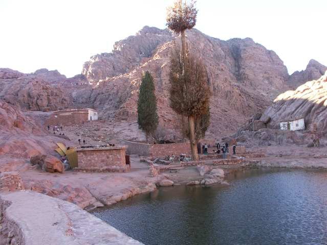
Site 12 - ELIJAH'S BASIN
This is a sandy flat, which lies between the northern extension of the mountain, Gebel Safsafa, and the summit and which breaks the 750 steps to the summit from the 3000 steps which descend to the Monastery.
A large thousand year old cypress tree, bare branched at the top, together with six younger cypresses and an olive tree, surround an ancient well which is fed by snow melt and occasional rainfall.
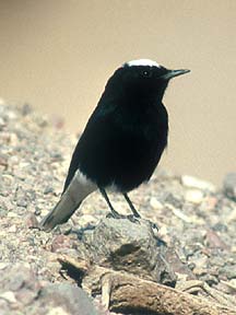
Below the well is a Byzantine dam which has been repaired recently. Constructed primarily to prevent flood damage to the Monastery, it also serves to recharge springs below. A lone Sinai hawthorn tree, frequented by small birds as the White Crowned Black Wheatear and the Sinai Rose Finch, stands near the dam wall.
Nature Note The White Crowned Black Wheatear (Bag'aa) is a small black bird, the male with a white crown and rump and a fluty call. It is very common and prefers rocky slopes.
The Sinai Rose finch (Gazam) spends the warmer months in the high mountains and is wintering in the wadis. This small seed-eating bird is often seen on Mount Sinai. Identified by its stout bill and melodious song, the male plumage is pink, the female is brown with a pinkish tinge.
The chalky white Church of Elijah commemorates the place where Elijah fled after killing the prophets of Baal and is mentioned by Etheria in the 4th century. Inside the church is the stone beneath which Elijah sheltered when he spoke with God (See I Kings 19:1-18).
Historical note Prophet Elijah (874 - 853 BC) warned the King of Israel that God would punish him with a drought for worshipping Baal; the worship of Baal was encouraged by Jezebel, daughter of the King of Sidonia and wife of Ahab. When the drought came, Jezebel had God's prophets killed.
Elijah then ordered that 450 pagan prophets prepare an altar to Baal, while he himself prepared one to God, saying "and the God that answers by fire, let him be God". The pagan prophets called upon Baal to no avail but when Elijah called upon God, fire descended and burned up the sacrifice. At this sign the people rose up and Elijah slew the 450 priests of Baal.
On hearing this Jezebel threatened to kill Elijah, who fled "unto Horeb, the mount of God" (a Biblical synonym for Mount Sinai). There God commanded him to anoint the new kings of Syria and Israel and Elisha to succeed him as prophet.
Incorporated beneath its roof is the Chapel of Elisha, an acolyte of Elijah. Opposite this is Daniel's Room, the shelter of the guardian of the church and summit in previous centuries.
The Church of Saint Stephen is located in the southern neck of the basin approximately 200 metres from the other churches. The church marks the cave where Saint Stephen lived; he was one of the confessors for pilgrims in the 6th century and his cloaked remains are in the ossuary at the Monastery.
Site 13, the Stairway down, starts to the right of the dam. (The Monastery can be reached in about one hour from this point.)
This path is spectacular but steep and should be walked with extreme care at night.
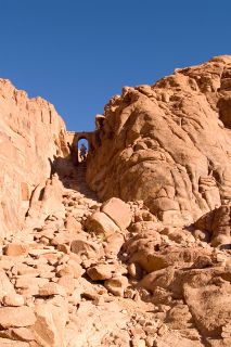
Site 13 - THE STAIRWAY OF REPENTANCE & ELIJAH'S GATE
Etheria records that in the 4th century The Stairsway of Repentance only extended part way up the mountain. Monastery records reveal that the stairway was completed by an anonymous monk under the patronage of Emperor Justinian in the 6th century. Monks have always believed that the mountain should only be ascended by those with the proper spiritual preparation and endurance for this steep but direct climb up 'The Stairway of Repentance'.
Bedouins call this route Sikkat Sayyidna Moussa (The Path of Our Lord Moses).
A hundred metres down the steps is Elijah's Gate; a faint inscription around the top of the arch reads John the Abbot and is believed to date from the 6th century.
Continue down 450 metres to Site 14.
Site 14 - THE GATE OF FORGIVENESS
In past times pilgrims confessed their sins to a priest at this gate and before ascending to the summit were asked: "Who shall ascend into the hill of the Lord? Or who shall stand in this Holy place?"
The pilgrim's response was from the succeeding verse in Psalm 24 - "He that hath clean hands, and a pure heart; who hath not lifted up his soul unto vanity, nor sworn deceitfully. He shall receive the blessing from the Lord, and righteousness from the God of his salvation." Pilgrims were then granted a certificate, a practice which continued until the 1880's.
Through the gate, at waist level on the right, is an inscription in Greek, possibly the word 'Stephanus' and an image of a hand.
Site 15 - CHAPEL OF OUR LADY OF THE STEWARD (OIKONOMISSA)
A little further on, you overlook the white-washed Byzantine chapel which stands approximately half way down from the summit.
The chapel is dedicated to a miraculous event which was reported in the 6th century.
The Oikonomos or Monastery steward, unable to obtain sufficient supplies to sustain the Fathers, climbed Mount Sinai to pray for the monks who had decided to leave the Monastery. The Virgin Mary appeared to him and promised that the storeroom would be filled. Descending from the mountain he saw a caravan of camels arriving laden with supplies from Palestine.
Another account explains that at one time the Monastery was so overrun with fleas, flies and ants that the monks could not "keep their corn or comfort there". All but two of the monks had left the monastery and they also had decided to leave after a final prayer on the summit of Mount Sinai.
On their ascent they encountered at this spot an apparition of the Virgin Mary who promised that they "would not lack what they needed for living" and that the insects would not torment them any longer. Following this, the monastery became free of pests and until recently, pilgrims attested to this miracle, claiming that "Certain unclean creatures like flies, wasps, hornets, fleas and others of that sort, cannot live there, nor come into the monastery from the outside. And it has been observed that if such creatures are introduced into the monastery, they instantly die."
The remainder of The Stairway of Repentance is flanked by eroded granite walls and massive boulders.
Take time to appreciate the changing colours, the extraordinary rock shapes and different views of the Monastery as you descend.
Site 16 - SPRING OF SYMEON
After 20 minutes you reach the Spring of Symeon, wedged between two large granite boulders and marked by a small popular tree. A stone bench looks onto the small dripping spring, surrounded by delicate mats of moss and maidenhair fern. This spring is reported to be the place where Saint Stephen baptized Jews in order that they pass The Gate of Forgiveness and ascend the Holy Mount.
The Gebeliya remember when this spring used to be much deeper and cleaner. The spring is now contaminated with rubbish and human waste; attempts are being made to clean and restore it.
You are near the bottom of the Stairway - Continue down the steps to the Monastery.
The religious significance and the long history of Mount Sinai and the Monastery have attracted visitors in the past and will continue to do so in the future. However, these sites are not primarily tourist attractions but the home and a place for worship for monks and pilgrims.
The Monastic tradition of hospitality means that all visitors are welcome, but the increasing number of secular visitors is placing a great strain on the monks and their religious lives.
If you decide to enter the Monastery, you need to dress (cover your belly, shoulders, arms and knees) and act in a respectful way and remember that visiting hours are strictly between 9 am and 12 noon daily, except on Friday, Sunday and Orthodox Holidays when the Monastery is closed to all visitors.
|